Caroline Street and the City Plan
|
|
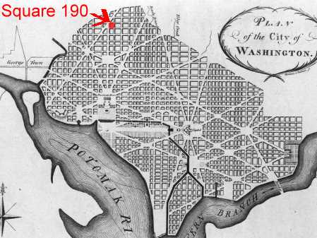
Caroline Street is a one-block long roadway running parallel with and between T and U Streets, NW, from 15th to 16th Street, in Square 190. It is near the northern edge of the original 1791 Plan for the City of Washington conceived by Major Peter (or Pierre) Charles L'Enfant. L'Enfant, who had had some training in architecture in France, originally came to America with other French soldiers to support the colonists' cause in their war with Great Britain. He served on General George Washington's staff and obviously impressed his commander-in-chief. Some years after the war, Washington, by then president, was personally overseeing the establishment of the country's new capital. He chose L'Enfant to develop a plan for the new city that would be part of the 10-square-mile federal territory straddling the Potomac River ceded from the states of Maryland and Virginia[1]
Major L'Enfant's 1791 Plan for the City of Washington covered an area that stretched from the confluence of the Potomac River and its Eastern Branch (today's Anacostia River) north along the Anacostia to an escarpment which had once been the shore of a vast prehistoric lake, then along the escarpment to the northwest and then southwest to Rock Creek, down Rock Creek, and then southeast down the Potomac back to the Anacostia.[2] L'Enfant named the roadway that he planned along the escarpment's base Boundary Street; we know it today as Florida Avenue. L'Enfant's plan called for the creation of numbered north/south streets and lettered east/west streets radiating outward - north, south, east, and west - from the location of the future capitol building. His planned street grid reflected variations in the existing terrain, which accounts for the difference in the size of the resultant city blocks.[3] On this orthogonal street grid L'Enfant superimposed a series of diagonal avenues.
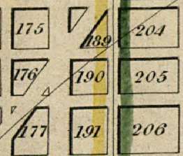
The squares, triangles, and reservations thus created were numbered. Square 190, bounded by 15th, 16th, T and U Streets, NW, is part of this original layout. Caroline Street as a roadway, however, was not part of that initial plan.
|
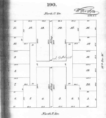
At some point plats (subdivision maps) of the squares were drawn. Below is an early proposal for a layout for Square 190. The lots were much larger than today's are, with all fronting on one (or at the corners two) of the main streets around the square. An alley system would provide rear access to all lots except those on the outside corners. (Square 205 to the immediate east of 190 was actually developed according to this plan.)
|
According to the Records of the Columbia Historical Society, the land on which square 190 and much of the surrounding area were eventually developed was once known as Flint's Discovery. Flint's Discovery was a land grant made on December 20, 1722, to one John Flint from one of the Lords Baltimore, the original proprietors of the Maryland colony.[6] By the time the District of Columbia was established in 1791, the northern tip of the city including Square 190 and a crescent down the west side including today's Kalorama and what we today consider Foggy Bottom was owned by Robert Peter. Under the terms of the agreement for the city, owners would deed the land for the streets and some of the squares to the Federal government, to be compensated by keeping part of the land for development. Robert Peter deeded what became Square 190 to the government. He kept for development scattered squares including 176 immediately west of 190.[7]
[1] For a more complete explanation of L'Enfant's role in laying out the City of Washington, see Worthy of the Nation, The History of Planning for the National Capital, by Frederick Gutheim, Smithsonian Institution, 1977. Pp. 2, 16-20.
[2] Source: Steve Coleman, Executive Director, Washington Parks and People, 2002.
[3] A good example of this difference in block or square size can be seen by comparing the distance between 17th and 18th Streets and that between 16th and 17th or 15th and 16th.
[4]Map of the city of Washington D.C.: established as the permanent seat of the government of the U.S. of Am. by James Keily, surveyor. Published Camden, NJ: Lloyd Van Derveer, 1851.
[5] Source: Real Estate Directory of the City of Washington, D.C., E. F. M. Faehtz and F. W. Pratt, 1874.
[6] "The Landscape of the Federal City," Don Hawkins. Washington History, Special Bicentennial Edition, Vol. 3, No. 1, Spring/Summer, 1991, p. 21. Allen C. Clark, "Origin of the Federal City," Records of the Columbia Historical Society, Vols. 35-36, 1935, p. 83 and 87.
[7] District of Columbia Original Land Owners 1791 - 1800 by Wesley E Pippenger, available at the Washingtonia Room, Martin Luther King Library.
Last update 9 July 2004
Copyright Richard Busch, 1993, 2004-5
Blanket permission for downloading and reproduction for personal use is given.
Any commercial use without explicit written permission is prohibited.