source: Highways and Communities
1955 - 1975: The Troubles
World War II gave an enormous boost to the region. From 1940 to 1943, the number of Federal government employees in the District grew from 134,000 to 281,000.[1]
The population of the District and region grew accordingly. While government employment decreased somewhat after the war, the population of the region just kept growing. The additional people needed houses. And increasingly they had automobiles that allowed them to commute substantial distances. New housing developments appeared in surrounding counties.
Those new suburbs spelled trouble for our neighborhood. The luxury apartment became an oxymoron, as those who could afford such a thing moved to mansions to the suburbs. Fine buildings like the Chastleton and Roosevelt became havens for those who could not afford the suburbs, and for new immigrants. Apartments were divided into smaller units. The Roosevelt eventually became a senior citizens home, and then stood empty for years.
And the new commuters demanded new roads.
The Inner Loop
American soldiers who saw Germany during and after World War II were impressed by the Autobahn (high-speed, limited-access highway) network that Hitler had created. Dwight D Eisenhower was particularly interested in the utility of such roads for moving military materiel quickly. There was a surge of interest in creating that kind of network in the US. The result was the Federal-Aid Highway Act of 1956, authorizing the construction of a national network of limited access, multilane highways - the Interstate system.
|
|
Unfortunately, American highway planners missed one very important aspect of the German system: Autobahns were (and are) built BETWEEN cities, but NOT through them. American highway planners decided that the network should connect city center to city center, and provide for circulation within the city. Plans were developed to cut highways through cities. And those plans were completed in many cities. The Interstates go through central Miami, Baltimore and Atlanta. For DC, the plan for I 95 was partially completed: what is now I 395 (Shirley Highway) from Springfield, across southwest and then north in a tunnel three blocks from the Capitol. The plan was to extend north from New York Ave to an interchange that was actually built where I 95 now meets the Beltway. (That final bit is not shown on the map above.)
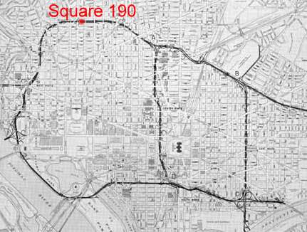
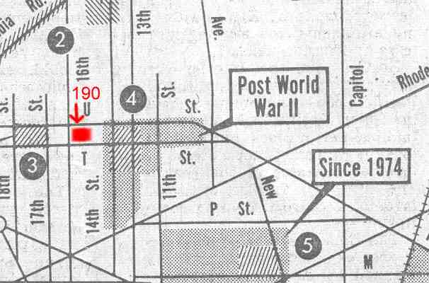
But our story concerns Caroline Street and Square 190. An inner freeway loop would have had a north leg that had Caroline Street as its center line.
While planning for the inner loop never progressed to the point of land acquisition in the U Street corridor, the very fact that the plan existed had a deadening effect on the vibrant Black city-within-a-city. Those who could moved away. Property values collapsed.
The Riots
|
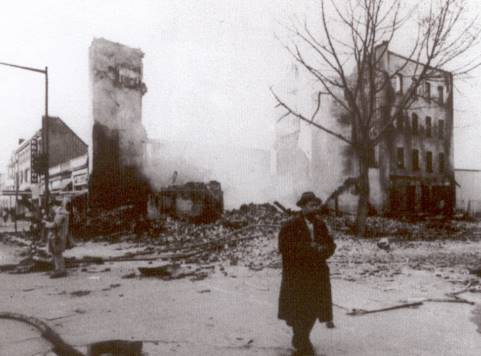
The 1960s were a time of turmoil in much of the US, as "We the People" began to include ALL the people. The assassination of the Reverend Martin Luther King, Jr, on 14 April 1968 triggered riots in many cities, including three intensive days in Washington. And as in many cities, the Washington rioters destroyed their own communities. The rioting in Washington apparently started at 14th & U, NW, and spread up and down 14th, and both ways on U. Some 1,000 buildings were burnt, 12 people killed. The thriving Black commercial and entertainment district along U and 14th was shattered.[3] The damage came as close to Caroline as 15th and U, but not to Caroline itself.[4] Most of the middle class fled. Many properties were simply abandoned, including 1916 and 1918 15th. One of the few Black-owned enterprises that survived was Ben's Chili Bowl.
The Drug Market
|
The destruction was followed by street crime on a massive scale. 14th and U was the center of a major zone of drugs and prostitution. Abandoned houses became shooting dens or whore houses. Entire blocks were devoid of normal citizens. By the mid 1970s the area to the east of Caroline could have been the source for many a Starsky and Hutch program. In fact we had a local police team very much like Starsky and Hutch, who provided their private phone numbers to citizens interested in cleaning up the area. They used 1916 15th as a lookout.[6], and once came to a block meeting.
But Caroline Street once again avoided the worst. Needles and condoms in the alleys were evidence that some enjoyed the relative privacy. But at the same time a different force was entering the area, people walking their dogs at all hours - and forming a Neighborhood Watch.
[1] "Employee Explosion Transforms Washington" by Peter Whoriskey, Washington Post, 25 May 2004 page B1.
[2] Then and Now Washington DC by Paul K Williams and T Luke Young, Arcadia Publishing, 2002, page 17. Original in Washingtonia Division, MLK Library, Washington, DC
[3] Ten Blocks from the White House - Anatomy of the Washington Riots of 1968 by Ben W. Bilbert and the Staff of the Washington Post, 1968.
[4] Interview with Mrs Caroline Evans, 2 June 2004.
[5] Detail of map from "Seven Major Drug Marketplaces Thrive in City" by Leon Dash. Second in a series, Washington Post 6 September 1976, pages 1 and 2. Map was drawn by Ken Burgess.
[6]Dan Gamber's personal recollections.
Last update 11 July 2004
Copyright Richard Busch, 1993, 2004-5
Blanket permission for downloading and reproduction for personal use is given.
Any commercial use without explicit written permission is prohibited.
home | previous page - evolution | next page - recovery | contact